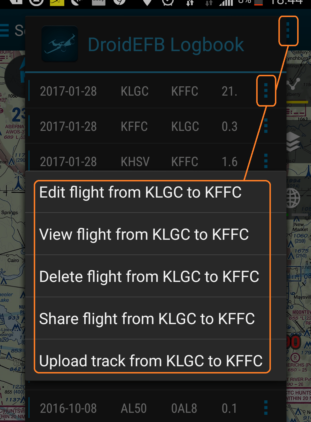
All flights are available to edit, view, delete, share and upload from within the DroidEFB Logbook.
By Microsoft, Fair use, https://en.wikipedia.org/w/index.php?curid=61017148
Tracklog Tutorial


Tracklog Tutorial
Overview
All flights are available to edit, view, delete, share and upload from within the DroidEFB Logbook.
Track Log is automatically started and stopped based on Airborne Threshold and Landing Decision Delay setting in Preferences. Optionally, tap the Flight Timer in the Flight Plan Tab to start or stop Track Log manually.
Manual Flight Timer operation is not possible while airborne or when GPS position is not available.
The DroidEFB Track Log feature is an added utility for uploading and viewing the recorded flight in either Google Earth for Desktops or Google Earth for Mobile. Here is an example of the 3-D flight path you can expect to see when viewing a Track Log with Google Earth:

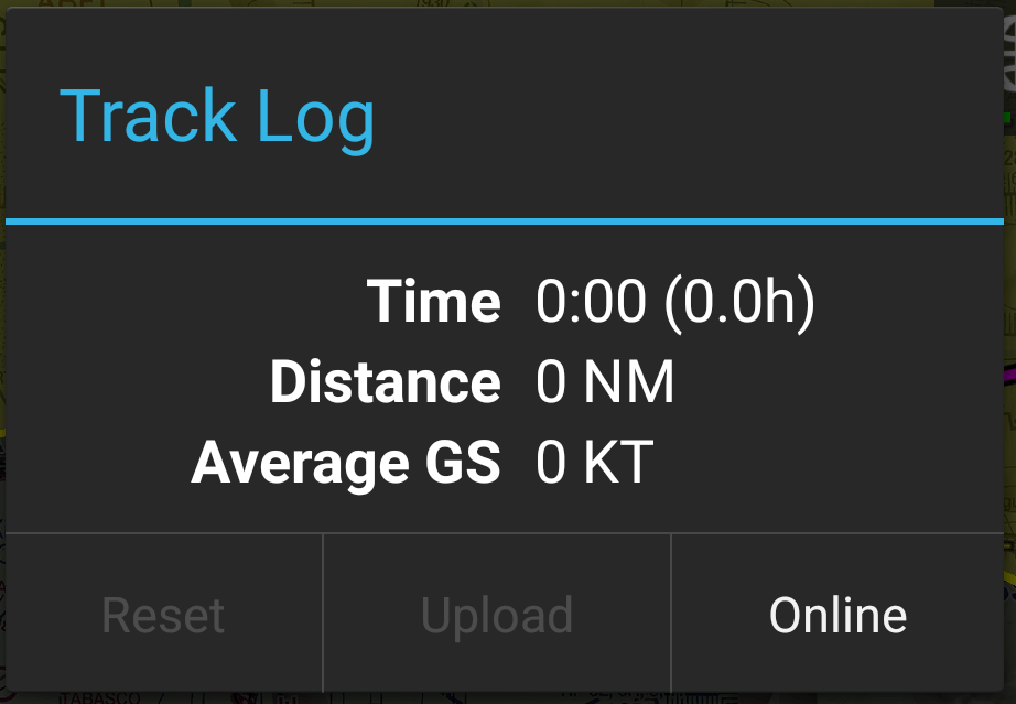
Track log recordings are automatic while DroidEFB is running and airspeed is greater than 30 knots (speed is adjustable in Preferences). To upload a track log immediately after a flight, navigate to Menu > Track Log within the app. Select Upload then Online to view the uploaded file. To upload a flight later, navigate to Menu > Logbook.
To upload a previous track log, navigate to Menu > Logbook within the app. Upload any Track Log data file to the web server where it is automatically translated to .kml files that Google Earth can open. Once opened with Google Earth, you may watch (play, pause, skip-forward/back) a replay of the flight path. Or, you may manipulate a particular flight path screenshot view by zooming in/out, pitching up/down, and yawing left/right to capture just about any view that you can imagine. Not only is a Track Log a great tool to critique your pattern and flight plan precision, but it also allows you to digitally capture and share an overview of those meaningful flights.
Lets get started on creating your own Track Log:
Before you begin you will need the following:
- The DroidEFB application running on your favorite Android mobile device.
- A valid GPS signal for tracking your flight path.
- Internet access – at the time you choose to upload and access your Track Log data file
- Google Earth for Desktops or Google Earth for Mobile for viewing your Track Log.
(Note: Google Earth for Desktops offers many more features and will open the .kmz/.kml Track Log files directly, whereas Google Earth for Mobile requires a simple “work-around” to open them. This is a current limitation of Google Earth for Mobile, not DroidEFB. I use Google Earth for Mobile for convenience.)
To Upload the Track Log file to the Web Server:
- Ensure that you have Internet access.
- Open the DroidEFB Menu.
- Select either Track Log to view current track status and Upload or select Logbook to upload a previous flight.
- Press the Upload option from either location. An “Uploading” status box will appear, followed by the message “Upload Successful – View at https://services.avilution.com/ss/skytracker”, near the bottom of your screen.
To Access the Track Log from Web Server:
- Navigate to “https://services.avilution.com/ss/skytracker“. The first time you access the site, you will most likely be prompted for your Google Username and Password credentials that you used for your DroidEFB subscription. Enter this info, and you will be directed to the page with your uploaded Track Log data. Don’t forget to bookmark this page for future access.
- Each line represents a separate Track Log file which is identified with a time-date stamp the instant you uploaded the file. You have the choice of downloading either a .kmz, .kml, or .raw data file. (Note: .kmz file may be empty. This is a known issue.) The “.kmz” file is a compressed version of the “.kml” file. (If you would like to learn more about .kmz and .kml files, read this link.
Opening the .kmz/.kml file with Google Earth:
- We are almost done! How you open the .kmz/.kml file depends on whether you are using Google Earth for Desktops or Google Earth for Mobile.
- Google Earth for Desktops: You can simply double-click on the .kmz/ .kml file to launch Google Earth and open the Track Log file. Or, you may launch the Google Earth application first – then use File > Open and navigate to your saved .kmz/ .kml file. In either case, you will start with a “satellite” view looking down on your recorded flight path. Double-click the “Fly this SkyTracker Log” entry within the open .kmz/ .kml file to launch the playback feature of your Track Log. If you would like to experiment with the .kmz/ .kml Track Log pictured at the beginning of this article, you may download it from here.
- Google Earth for Mobile: To launch the .kmz/ .kml file with your Android mobile device, Gmail the .kmz/ .kml file as an attachment to yourself. Open the Gmail message with your mobile device and save the attached .kmz/ .kml file. Then, choose the “View” option for the attached file. This will launch the Google Earth for Mobile application and open the Track Log file in playback mode. I have had no success just double-clicking on the .kmz file with my Android tablet, and you do not have a File > Open option within the Mobile version of Google Earth, so try the Gmail attachment method described above.
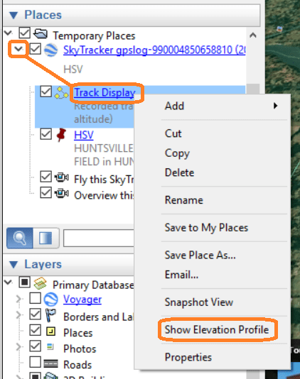
View Elevation Profile in Google Earth:
Google earth offers many additional features that can be used while viewing your Track Log, such as viewing an elevation profile. To do this, simply expand the file in Google Earth, right click on Track Display and select Show Elevation Profile.
These steps should get you started with the DroidEFB Track Log feature. Recording your flight path is a great built-in feature of DroidEFB. If you haven’t done so already, I encourage you to give it a try.